Dear Reader,
In September 2024, I was invited to conduct geoheritage walks by the Mangalore Heritage Group. While Mangalore’s topography is shaped by laterite (I’ve written about lateritic landscapes before), I was more keen on visiting St. Mary’s islands, near the town of Udipi in south India. Accessible by a ferry from the fishing docks of Malpe near Udipi, these islands with unusual volcanic formations, are a popular tourist destination and film shooting location. Beyond a small, largely ignored sign, there’s little appreciation for these islands’ deep-time secrets; they hint at a time when India and Madagascar began unzipping and whisper tales of how some species hitched a ride, migrated and evolved across these landmasses.
In this edition, I hope to retrace the story of underwater volcanic eruptions, species migrations, continents rifting and drifting, and how the St. Mary’s islands are part of an ~88 million-year jigsaw puzzle.
Video Teaser: Here’s a ~4 minute video with drone footage of the islands, captured during the walk with the Center for Advanced Learning (CFAL) students in Mangalore.
Let’s time travel,
Devayani
About St. Mary’s Islands
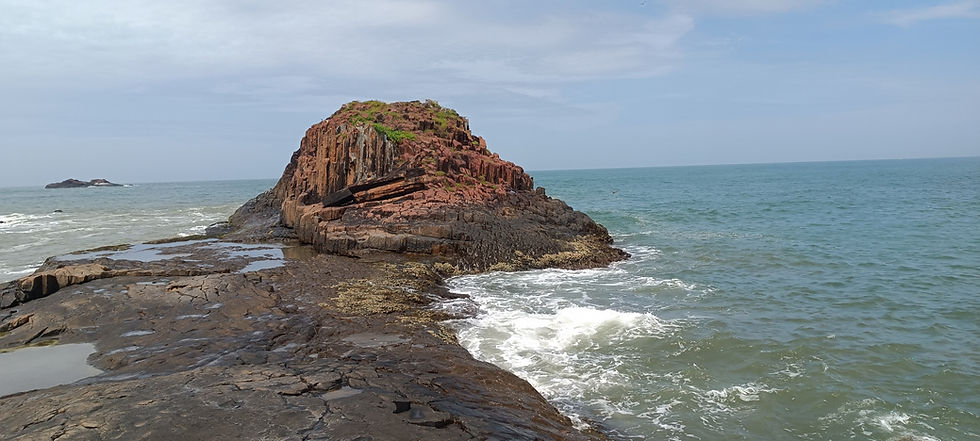
A half-hour ferry from Malpe near Udipi, off India’s western coast, takes you past the St. Mary’s islands. Four small fragments named Coconut, North, Daryabahadurganj, and South islands form a roughly six-kilometre archipelago which runs roughly parallel to the coastline and rises no more than 10 metres above sea level. The St. Mary’s islands were declared a National Geological Monument by the Geological Survey of India (GSI) in 1979. Yet, the bi-lingual sign by the Ministry of Tourism doesn’t mention this at all, nor does it give a very clear explanation of the island formation.
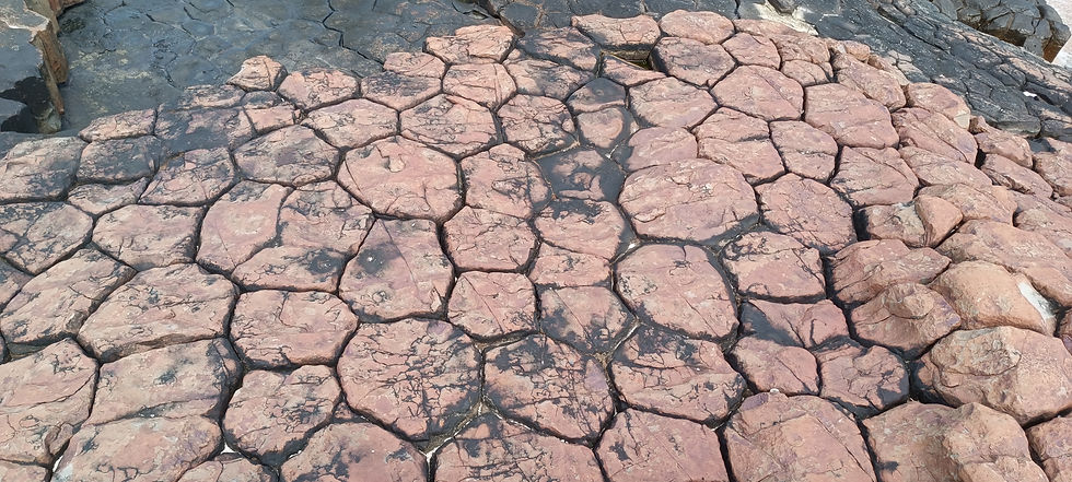
Of the four islands, Coconut island is the only one accessible to the general public, and it is said to have the most spectacular columnar jointing formats. On the ferry ride, hexagonal pillars jut out like angled stakes, hinting at more formations underwater. Image Credits: Devayani Khare.
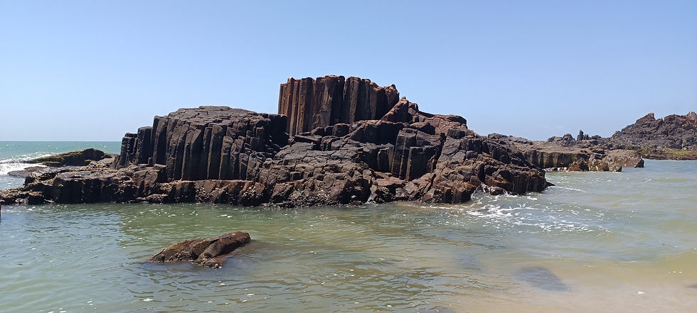
There are a few hexagonal, columnar volcanic structures in India, though not as well-known, most are part of the Deccan Traps formed around 67-64 million years ago. For example, Gilbert Hill in Andheri, Mumbai in Maharashtra, the Kavadia Pahad near Pipari village in Madhya Pradesh, and several in Telangana.
Yet what’s unusual about St. Mary’s formations is that they date back to an ~88 million-year-old volcanic eruption that caused the drift between the Indian subcontinent and Madagascar.
A close-up of the wave-worn and weathered hexagonal structures that resemble a causeway. These extensive formations cannot be found anywhere on the mainland near Udipi, and are the only coastal occurrence of columnar basalts in India. Image Credits: Devayani Khare.
In northern Ireland, the Giant’s Causeway — an expanse of 40,000 interlocking basalt columns created during a ~60 million-year-old volcanic fissure eruption — is recognised and protected as a UNESCO World Heritage Site. The dramatic formations inspired legends of giants, like Finn McCool, striding over this causeway (hence the name) and across the sea to reach Scotland.
If only India could follow in these footsteps and have a better appreciation for our incredible geoheritage sites and the stories they whisper.
The Unzipping of India & Madagascar
Our story begins around 180 million years ago, in the Jurassic Period, when the supercontinent Gondwanaland split into western (Africa and South America) and eastern (Greater India, Australia, and Antarctica) halves, and started rifting.
Around 130 million years ago, in the early Cretaceous, the eastern chunk further split apart, and Greater India, with Madagascar still attached, broke off from Australia and Antarctica. The term ‘Greater India’ has different connotations in history, yet in this context, it denotes the Indian subcontinent comprising present-day Pakistan, Bangladesh, Myanmar, Bhutan, and Sri Lanka, as well as Seychelles and Madagascar.
Roughly 88 million years ago, Greater India reached the Marion hotspot, located below present-day Marion island, roughly 2,400 km or 1,490 miles south of present-day Madagascar. Magmatic eruptions from underwater volcanoes bubbled to the surface and spilled over the basement rocks. When exposed to air and saltwater, this magma slowly cooled, cracked and contracted to create hexagonal columns like those seen at St. Mary’s islands. This phenomenon is known as columnar jointing and occurs commonly in volcanic rock. St. Mary’s islands, in a sense, are the visible remnants of the Marion eruptions in India. Similar columnar formations can be seen along Madagascar’s coast at Vatomandry and Ilaka.
As the pressure along the hotspot built up, a mountainous section atop this massive landmass began to unzip, giving rise to India’s sheer Western Ghats or Western Escarpment, and Madagascar’s central highlands known as the Angavo Entrapment. Interestingly, the mountain belt had a ~30-km gap or pass, which persists as the Palakkad Gap in India and the Ranotsara Gap in Madagascar — these gaps indicate that the mountain belt between these two landmasses was once conjoined. The final intriguing piece of this puzzle lies in the river patterns; most rivers that rise in the Western Ghats flow eastwards towards the Bay of Bengal, whereas Madagascar’s major rivers flow westwards from the central highlands.
Genetic comparisons of India and Madagascar’s biodiversity have provided more tantalising evidence for Greater India’s rifting. Despite Madagascar’s proximity to Africa, its flora and fauna bear more similarities to India’s biodiversity than to Africa’s; even fossils bear the same resemblance. Palm trees (Coryphoideae), carnivorous lineages like sundew (Drosera) and the fly-trapping pitcher plant (Nepenthes), and woody vines (Celastraceae), are just some of the plants that thrived on India-Madagascar before they split. Molecular comparisons of the Etroplus (known as pallathi in Malayalam, eaten in parts of Kerala) from a family of freshwater and brackish-water fishes known as cichlids, have indicated that their nearest relatives are in Madagascar.

The endemic, subterranean Indian purple or pig-nosed frog was discovered in 2003, and has since been recorded across the Western Ghats. Image Credits: Karthickbala via Wikimedia Commons (CC BY-SA).
Then around 65-62 million years ago* (please refer to the erratum below), a northern chunk of Madagascar broke off and disintegrated to form the Seychelles islands, located in the western Indian Ocean. The Sooglossidae frogs in the Seychelles have a close relative, the Indian purple frog (Nasikabatrachus sahyadrensis), found in the Nilgiri Hills in south India, which bears testimony to this rifting. The Sooglossidae frogs in the Seychelles have a close relative, the Indian purple frog (Nasikabatrachus sahyadrensis), found in the Nilgiri Hills in south India, which bears testimony to this rifting.
Together, the presence of columnar formations on both landmasses, the jagged edges of the mountainous belts with their telltale gap, the river networks and biogeography are all key pieces in a puzzle that lends credence to Alfred Wegener’s continental drift theory.

A map showing the hotspots and ridges formed during the transit of the Indian plate. The Marion and Reunion hotspots are particularly relevant to the India-Madagascar puzzle. The inset shows the area affected by Marion plume's outburst, which led to the separation of Madagascar from India. Image Credits: Arora, Baldev, Subba Rao, P.B.V (2002).
For a deeper appreciation of this puzzle and the continent's drift since then, plot the distance between Marion island and Vatomandry on Google Maps. That’s how far India and Madagascar travelled before tearing apart. Then the Indian subcontinent turned anti-clockwise ~30 degrees and moved further north. Along the way, it also passed the Reunion hotspot — the cataclysmic event that led to the formation of the Deccan Traps and has been implicated in the extinction of the dinosaurs (the asteroid may have been the final straw, but new research indicates it wasn’t the sole instigator). Then, around 55-60 million years, India collided with Eurasia, and the ever-rising Himalayas defined this plate boundary interaction.
Mythical Lands: Lemuria and Kumari Kandam
Remember I’d mentioned the migration of certain species from India to Madagascar, when the landmasses were connected? Interestingly, some species also travelled over from Africa to India, via Madagascar — strepsirrhine primates, ancestors of the bush-babies (Africa), lorises (South India, Sri Lanka and Southeast Asia) and lemurs (Madagascar) are notable examples.
In 1864, in a valiant attempt to explain the presence of lemur-like primates on these now-disconnected landmasses, the British zoologist Philip Sclater hypothesized that there once was a land bridge named Lemuria between Africa, Madagascar and India.

A hypothetical sketch of the origin and of the diffusion of the 12 varieties of men from Lemuria, the cradle of civilization, over the earth. Image in the public domain.
Soon after, the Lemuria hypothesis gained favour in Tamil Nadu, south India, when the Theosophical Society championed it, and drew parallels to Kumari Kandam. Kumari Kandam, legend had it, was an ancient but highly advanced society (much like Atlantis) that represented the cradle of civilization and was an isolated continent located in the Indian Ocean. As Lemuria was said to straddle the same waters and might have been submerged in much the same way Kumari Kandam may have, the hypothesis was propagated fervently. Apart from being introduced via college curricula (where it persisted in Tamil textbooks as late as 1981), it was used by historians and politicians to highlight the great antiquity of the Tamil folk.
As more evidence emerged to support the continental drift theory, the Lemuria hypothesis became an amusing chapter in human incredulity. Even though the idea of a massive land bridge being submerged over time sounds plausible, I think the geological puzzle of India and Madagascar is far more incredible and awe-inspiring. To imagine continents rifting and drifting apart over millions of years, is surely more fascinating than sunken mythical lands? And more deserving of a place among India and the world’s geoheritage sites!
Erratum:
In a previous version of this article, I mentioned that the breakup of the India-Madagascar-Seychelles occurred ~90 million years ago. The correct date is around 65-62 million years ago. [Reference: Age of Seychelles-India breakup, Collier et al.] I sincerely apologize for the error.
Resources:
[Watch] When India Was An Island by PBS Eons
[Read] Indica: The Deep Natural History of the Indian Subcontinent by Pranay Lal (Chapter 7 - Isolation, specifically from page 187 onwards)